
Monitoring nitrogen application with VENµS
in the northern Negev, Israel
2Dept. of Vegetable and Field Crop Research, Research, Agricultural Research Organization
In traditional farming irrigation and fertilization are applied uniformly in the field. Precision farming monitors the in-field spatial variability, thus enabling irrigation and / or fertilization according to the local (in-field) need. One way to assess the need for fertilizer application is by using reference strips. Base nitrogen (N) was applied in reference strips in commercial fields in the northern Negev, Israel
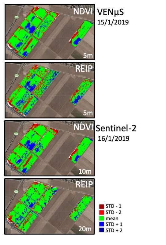
To monitor the spatial variability of agricultural crops we used vegetation indices (NDVI, REIP) from Sentinel-2 (10/20m, five days revisit time) and VENµS (5m, 2-day revisit time) satellites (Fig. 1). We used the Google Earth Engine platform to map the spatial variability of each field by calculating the mean VI, masking extreme values (three standard deviations, 3σ) of each field, and presenting the anomaly as deviation of ±σ and ±2σ.
The high temporal and spatial resolution of VENµS enables monitoring agricultural fields during the growth season better than the lower resolution sentinel-2 data. Moreover, Sentinel2 was unable to provide information due to cloud cover more often, and especially when top dress N application decision were taken. The high spatial resolution of VENµS Red-Edge band was very useful for detection of in-field anomalies. Hence, VENµS shows advantage versus Sentinel2 in representing the variation within fields and decision making
Fig. 1

Powered by Eventact EMS